1500 shaares
4 private links
4 private links
3 results
tagged
maps
Get started with the OpenStreetMap desktop editor
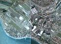
JuxtaposeJS helps storytellers compare two pieces of similar media, including photos, and GIFs. It’s ideal for highlighting then/now stories that explain slow changes over time (growth of a city skyline, regrowth of a forest, etc.) or before/after stories that show the impact of single dramatic events (natural disasters, protests, wars, etc.).
Khartis was born from a finding: how to make a thematic map just in few clicks, keeping requirement and scientific rigor in data processing? The team behind Khartis has refined this idea in teaching situations, research or map production.